Showing posts with label industrial architecture. Show all posts

Wednesday, July 04, 2007

Tib Street, Manchester
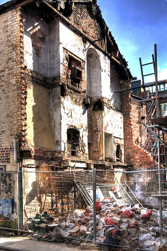

Tib Street, Manchester, originally uploaded by fotofacade.

Some comments extracted from flickr about this image make interesting reading. It is sad to see such a building disappear and yet fascinating to voyeuristically for a short moment in time peep into part of somebody's life and see the material remains of their existence. I imagine them strutting there stuff like an actor on a stage set.

view profile
kayork Pro User says:

This sort of picture always makes me sad.
Posted 24 hours ago.

view profile
fotofacade Pro User says:

It is sad - but also fascinating to see the blueprint of the whole elevation of a house and to think that somebody actually lived there - it was a home.
Posted 24 hours ago. ( permalink | delete | edit )
view profile

linfrye Pro User says:

My gracious ....it is always intriguing to see how others think and live ... I wonder as your words above prompt me, how these folks got through their days, what they thought, felt, did. Your photo is very evocative ....and prompts much thought...
Posted 21 hours ago. ( permalink | delete )
view profile

fotofacade Pro User says:

Yes Lin - it's like taking the front off a dolls house and having a peep. This sort of stuff always fascinates me.

Posted 21 hours ago. ( permalink | delete | edit )
view profile

Claire Howson Pro User says:

Fantastic shot of dereliction and development. It's great that you can still see the fireplaces.

Posted 3 hours ago. ( permalink | delete )
view profile

jonwild Pro User says:

I like the doll's house analogy, it is fascinating to peek inside and imagine how it was. Incidentally, Matthewbailey has a great example of eclectic decoration from a different time laid bare here.

Monday, September 25, 2006

Darnall Crucible Steel Works

On Saturday I visited the Darnall Crucible Steel Works which was organised by Ray Wilson as part of a SPAB visit. The site, where crucible steel was produced, is now a Scheduled Ancient Monument. I have put together a microsite here with more information and access to photo's and links.

Below is a tabblo photostory of the days visit. Click on the image to get a larger view.

PS. Thanks to Sue for the lift into Sheffield!

Tabblo: Darnall Crucible Steel Works


Friday, September 01, 2006

Ancoats Manchester Archivid

Here's an archivid of my most recent work in Ancoats Manchester, UK. Ancoats was the world's first industrial suburb, and is undergoing a regeneration programme which has introduced a mixed use of contemporary architecture combined with a re-use of the historic industrial heritage. More here...

Tuesday, April 11, 2006

Croston's Gate Post


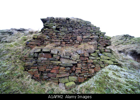
The site of Crostons Upper Mill is slowly being reclaimed by nature but significant standing archaeology remains such as this gate post which is situated next to the rubble outline of the cottages it once served.

Crostons Upper Mill is being photographed as a part of my Cheesden Valley Project

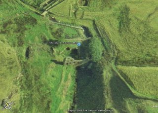
There is a google earth archi-map of the Cheesden Valley

More images of the Crostons site

All images of the Cheesden Valley project by Andy Marshall

Wednesday, April 05, 2006

Oriel Chambers,Liverpool UK

Oriel Chambers by Peter Ellis 1864 Liverpool UK is the subject of my latest sale to an architecture book.

It is a remarkable building which predates the modern style of construction both in its form and its style. It is a revolutionary design

The image can be purchased from Alamy

Friday, March 24, 2006

The Lodge at Four Acre

How about this for an archaeological profile? This must be an archaeologists dream with the full section exposed and not much digging to do!

This is an eroded section of the lodge bank at Four Acre Mill in the Cheesden Valley Heywood near Lancashire. It is adjacent to the outlet where the water would have driven the water wheel at the Mill situated a matter of yards lower down. The lodge was built before 1810 for the mill which started its life carding and spinning wool. Remains still exist of the mill amounting to a low rubble wall and much scattered debris. A hole which I think might come from the tail race in the bank below is taken up by a fox or badger.


In the photo above you can see the full outline of the lodge and the indentation where water would have collected to power the waterwheel.

The valley is full of the signs of mans endeavours to utilise the landscape to help him prosper. It was only recently that I noticed a whole range of
ridge and furrow around the area known as Tom Hill.

I am currently carrying out a project to photograph the Cheesden Valley and it has its own
separate blog.

There is a Google Earth map of the valley which I have created.
You can download it at my archi-maps page here.

Tuesday, March 14, 2006

River Aire Leeds


I am amazed at the tide of redevelopment and regeneration of the industrial architecture along the River Aire in Leeds near to the centre. This photo is one of my latest sales to a magazine in the UK.

More photos of Leeds

Monday, March 13, 2006

Below the bridge at Crostons

This was the scene a week ago or two, below the bridge (more like a conduit) at the site of Crostons Upper Mill in the Cheesden Valley Heywood Lancashire UK


Wednesday, March 08, 2006

The Lodge at Mr John's

Here are the remains of the lodge used to drive the mill at Cheesden Lumb Higher (affectionately known by contemporaries as Mr John's). The lodge isn't so easy to see during the summer and the snow helps add a little relief to see the contours. It lies empty now, but I imagine it would be treacherous to try and walk into the centre. In the south east corner lumps and bumps reveal the site of the mill. Directly to the south a wall stands with holes inserted at regular intervals where the rafters would have been lodged to support the floor.

Andy Marshall is part way through a project to photograph the sites of the Cheesden Valley near Heywood Lancashire UK

Saturday, March 04, 2006

Cheesden Lumb Even Lower

I went out the site of Cheesden Lumb Lower today because it had snowed the night previously and it helps define much of the archaeology.

Recently I have noticed a deterioration of the site which seems to have been made worse by a surge of water or flooding of some kind. Where the axle to the waterwheel was - we now have huge sandstone rocks and boulders. To the front of the mill the earth has caved in leaving a large circular chasm. The foundations beneath the doorway have been revealed and I can't help feeling that it wont be long before the facade collapses.


Andy Marshall is part way through a project to photograph the Cheesden Valley - more here...

Monday, February 27, 2006

The Making of the English Landscape


Would it be sad to say that one of my 'comfort' books is 'The
Making of the English Landscape' by W G Hoskins. I think I read in the flyer that one critic said that it was rare that a single book comes along and heightens your consciousness of your surroundings. That's why every now and then I have to dip back into it to bring me back to that ethereal state of awareness - or else I'm in danger of being numbed by the effects of today's busy and stressful lifestyle.

I think the book was originally written in the 1950's but it is still revolutionary in its outlook - with its main tenet that even the wildest moors of Britain have been shaped by the hand of man. Even more remarkable is the fact that with a little insight you can still see the marks that our ancestors left over 10,000 years ago.

Boundaries are one of the most lasting features in our landscape, as are some field systems.

The photo above of
Cheesden Pasture in Heywood Lancs shows a largely rural scene which most would expect to be completely natural. But we have a field boundary of stone; a cultivated pasture to the right; a tree (which is at the base of the ruins of a house and probably planted by man); just off photo, some larger humps and bumps were created in the late C18th and early C19th when water was diverted to a lodge to run a water powered mill. On the side of the hill in the background there survives a series of ridge and furrows which are only visible when the sun is low (from what period I don't have a clue). The main ridge in the photo leads to a hill which has had human activity for thousands of years with stone age flints being found (possibly a place of ritual) Nearby across the Edenfield Road we have a bronze age burial site which lifts the field boundary aloft like the dip of a roller coaster. Only a matter of yards away the head of a bronze age axe was found during excavations for a reservoir.

Indeed it wouldn't surprise me to find out that this area of North Pennine Moors was teaming with life several thousand years ago and that the location of my home town would have been no more than a clearing swamped and surrounded by trees.

Monday, February 06, 2006

Cheesden Valley Project - Cheesden Pasture Mill


History

Built around 1810 for carding and spinning wool. The mill was powered by water from the large triangular lodge situated several feet above the mill. It converted to cotton spinning in the late 1830's whereafter the factory was enlarged to incorporate several thousand spindles. Sandiford and Asworth note 3 to 4000 spindles for spinning cotton waste yarns, 3 pairs of mules for spinning raw cotton and 5 reeling frames for winding the spun yarn into hanks in preparation for the dyer. In addition 30 looms made cloth from the spun yarn.

Here we can witness in one mill the transition from industrial unit focusing on producing wool for the outworker, to multi-faceted industrial unit focusing on producing cloth in a variety of forms and ranges - reeling in the majority of processes under one roof.

During the peak of its production a row of cottages were built to house workers. Later a steam engine was incorporated into the factory which helped produce gas to light the mill. A school room was also incorporated indicating the important role of the mill in the northern outback, in social matters during this time.


Remaining Archaeology

Little remains of the mill (although more than I expected). The plan form can still be made out (if one consults Sandiford and Ashworths drawings) against the hillside. The biggest remaining impact of the mill is on the landscape, with the huge earth banks of the lodge rising high above a rubble stone revetement. It remains empty, and was filled by the numerous springs in the area, and not the brook itelf. An opening in the south west corner indicates where the waterwheel must have been. Also, a large oval indentation is present to the north which may have housed a boiler or gas tank of some description. Whilst I was up there I found the remains of a china tea-cup (surely not from the mill or outworkers buildings?). Iron pipes protrude from behind a stone revetment or wall tucked up against the lodge. Beyond the great oval indentation the stone remains of a square building survive. To the east of the lodge, humps and bumps and some slight standing walls indicate the location of the row of houses. Of interest to me are the remains of a
Shippon which looks suspiciously like a ww2 air raid shelter.


Project Links

Touched by the hand of God
Shippon at Cheesden Pasture Mill


Lightbox (updated regularly)

Images of Cheesden Pasture Mill

Location

You can view all of the Cheesden Valley mills on my Google Earth archi-map.
Access is from my archi-map page on my website.


Satellite Image of Cheesden Pasture courtesy of Google Earth


Do you have more information?

Please post a comment if you have more information or any corrections are required

References

There are a number of references which require acknowledgement. Firstly the pioneer book by A.V. Sandiford and T.E. Ashworth called The Forgotton Valley is an important source of information and is available from the libraries at Heywood or Rochdale. For a general background Owen Ashmore's Industrial Archaeology of Lancashire is a must. There is also a good archive at Heywood Library.

Thursday, February 02, 2006

Latest Sale

This image sold this week in a variety of media for educational use and cd-rom. It is of the Rochdale Canal next to Canal Street in Manchester city centre, UK.

Wednesday, January 18, 2006

Cheesden Lumb Lower


More notes on my Cheesden Valley Project....

Cheesden Lumb Lower


History

Cheesden Lumb Lower was one of the first mills in the valley built in or before 1786. It was water powered and originally set up as a woollen mill. As times changed it became a cotton mill. In an advert of 1809 it is listed as having a perching mill, blueing house, teaster and belonging tenters, and a stove house where sulphur dioxide fumes bleached woollen cloth for blankets. A carding engine was also introduced in this period. In 1838 the mill still had a set of stocks (fulling?) but the teaster and percher were abandoned. Spinning machinery was introduced.

Remaining Archaeology

As is visible in the photograph above, the facade remains to much of the front elevation. Photographs do exist of the full mill in Heywood Library. North of the facade there is an indentation which is possibly where the stove was situated. Remarkably, the axle to the waterwheel still survives, now embedded in overgrowth. Look out for the Dolphin carved in stone at the bottom of the front facade near to the water. Apparently a local artist did this.

Project Links

Cheesden where?

Lightbox (updated regularly)

Images of Cheesden Lumb Lower

Location

You can view all of the Cheesden Valley mills on my Google Earth archi-map.
Access is from my archi-map page on my website.


Satellite image of Cheesden Lumb Lower, courtesy of Google Earth


Do you have more information?

Please post a comment if you have more information or any corrections are required

References

There are a number of references which require acknowledgement. Firstly the pioneer book by A.V. Sandiford andT.E. Ashworth called The Forgotton Valley is an important source of information and is available from the libraries at Heywood or Rochdale. For a general background Owen Ashmore's Industrial Archaeology of Lancashire is a must. There is also a good archive at Heywood Library.

Sunday, January 08, 2006

Four Acres

Walked up to the site of Four Acres Mill today with my son Sam who is here stood on the southern rampart of the mill lodge which was built several feet above the mill to provide the pressure to drive the water wheel. The wheel pit still remains, although much filled in with stone. At the site of the exit for the water from the pit (now much covered) there is a singular hole now occupied by a fox or badger.

In the photo, behind the tree you can see the spurs of the banks of the Cheesden Brook which sidles its way down the moors.

You can view the archi-map with four acres mill highlighted here.

Cheesden Valley Project

Saturday, January 07, 2006

Shippon

Up to Cheesden Pasture Mill yesterday for the first time. It lies north of the Edenfield Road and you have to get over a high stile into the field to be on your way. I just about made it after falling over the stile and almost losing all my camera equipment. It was worth all the effort though, because the site still shows the remains of the mill and lodge which started its life in around 1810 and finished in the 1890's.

Now within the lumps and bumps is another vernacular curiosity. Built of concrete (I would say post war) a shippon lies to the southern end of where the mill was. I loved it - almost cathedral like in its form with its nave like arches spreading upwards to shroud the sheep in warmth and solitude. To the exterior its bitumined hide which reminds me of the
upside down boat cabins on Holy Island (photo courtesy of p smithson).

You can see all the mills on my archi-map of the Cheesden Valley

Cheesden Valley Project

Friday, January 06, 2006

Cheesden Archi-Map

For those who have been wondering what I have been going on about over the last few blogs - heres a Cheesden Valley Archi-Map to check out the mills of the valley. The mills developed in rough chronological order, from north to south.

Try tilting the google earth map to see the terrains lumps and bumps (check the terrain radio button to have this work). You can boost the terrain bumps by going to Google Earth Options and increasing the elevation exaggeration to 3. This way you can fly through the valley in 3d and see the mill locations. I am updating each location with detailed information. Just the washwheel mill is ready (look for the 'i' symbol)

Also have added a data-sheet about the Washwheel Mill on my Cheesden Valley blog.

Thursday, January 05, 2006

Cheesden Home

Just to let those that are interested in my Cheesden Valley Project I have set up a separate blog which will act as a conduit for all my Cheesden information. I will carry on posting about this remarkable valley here but also post it on this site so that the information is all together in one place.

The above picture is of the remains of
Deeply Vale Mill which is one of 15 sites in the Cheesden Valley.

Friday, December 30, 2005

Below the bridge at Cheesden


No, there wasn't a troll but there is a spirit of kinds - the spirit of mans endeavours and of civilisation lost. Not a soul in site - look into the distance and you can see 2k's worth of camera equipment left out in the open - just how isolated this location is.

Remember 'Planet of the Apes' - at the very end (or was it at the beginning?) when the man turns up at the beach and sees the Statue of Liberty derelict on the floor? Just what I felt like during the soggy hour I spent yesterday, beneath the crumbling C19th pack horse bridge.

See the carved and patterned coping? Testament to what our forbears thought of their utilitarian and industrial environment. Kudos to them eh?

Thursday, December 29, 2005

Cheesden again

Hiked it over to the Cheesden Valley today amidst the icy blasts and snow. The valley is time frozen, in a state of serene industrial archaeology ranging from the remains of an C18th waterpowered mill (with wheel shaft still intact) to the latest state of the art C19th mill further down the valley. All in all we have the full gamut of industrial development of the cotton industry represented in this 2 mile valley. Here we still have the tangled stone, slate and iron remains of over 14 mills. Here we have the remains of a Dickensian industrial landscape with lodges, tailraces, and weirs.

I spent a pleasurable hour photographing sculpted and patterned stone parapets, now half submerged beneath the pack horse bridge in the stream. Further down the valley near the remains of the Deeply Vale Mill there lies a classical stone pediment, once proudly situated over the door of 'the old house' .

The valley has survived because it is so difficult to get to. It is being allowed to decay over time and there is no central interest at present looking after it.

My aim is to record as much of the remaining features as possible before they disappear. I am going to put them onto a Google Earth map just like my Manchester one.

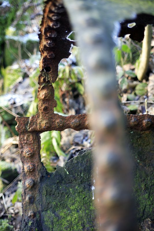
I particularly wanted to photograph one mill today called Washwheel Mill situated half way down the valley and built around the mid C19th. The chimney remains as well as the scouring becks and corroded pipe (photo above) linking the lodge with the mill.

I took a landscape photo of part of the valley today and I have put it onto my photoblog site. You can view it here.

I

ARCHI-SEARCH

Custom Search