Showing posts with label archimaps. Show all posts

Wednesday, August 23, 2006

Mapping The Historic Environment

Above is a photo I took in Lavenham, Suffolk UK in 2005. I have compiled a series of images and geo-referenced them on an archimap which can be viewed with the free google earth download. Lavenham is a wonderful example of a medieval wool town with a whole rack of timber framed buildings. I have geo-referenced them on the archimap.

It is a wonderful way to view architecture. You can download the map for free here. There is also a Manchester map and a Cheesden Industrial Valley Map.
Curiously in the Lavenham archimap I have highlighted a site which looks potentially archaeological. What do you think?


Andy Marshall is a professional architectural photographer. Most images can be downloaded 24/7 at Alamy

More about Andy Marshall
Contact Andy Marshall
Search all of Andy Marshall's Images

All images are copyright Andy Marshall and must not be used without prior permission.

Friday, June 23, 2006

ARCHITECTURE WEEK: ARCHI-MAPS


Architecture week is celebrating its 10th birthday, and what better way to celebrate the event than checking out one of my archi-maps.

Archi-maps are based upon google earth (the free dowload) and provide a reference point for key buildings with information, links and photographs. Currently, I have 3 archi-maps in progress including, Manchester, Cheesden Industrial Valley and the timber framed buildings of Levenham.

To download these maps and to find out how to view them
go here


The latest addition to the Manchester archi-map is the Beetham/ Hilton tower by Ian Simpson Architects completion 2006. You can view its location and access photographs and information about the tallest residential building in Europe.

The Manchester archi-map also has buildings dated into the century that they were built - so that you can view various periods of construction in isolation by clicking on each century folder.


Andy Marshall is a professional architectural photographer. Most images can be downloaded 24/7 at Alamy

More about Andy Marshall
Contact Andy Marshall
Search all of Andy Marshall's Images

All images are copyright Andy Marshall and must not be used without prior permission.

Friday, January 13, 2006

Archi-Maps Update


There's a lot been happening with my
archi-maps project recently. The maps include photographs and links to relevant information. To use the archi-maps you need to have the free Google Earth installed. If you haven't seen Google Earth you'll wonder why you ever did without it. To get into Google Earth there's a great blog here. To download any of the maps go to my archi-map page : buildings are being added regularly so use the update feature on the page to keep up to date.

Manchester, UK archi-map


Manchester was the industrial hothouse of England during the Industrial Revolution and is now at the forefront of urban design with new structures by world renowned architects such as Calatrava and
Ando.

More buildings have been added to my
Manchester archi-map , the latest being the Victoria Bridge near the Cathedral. All buildings have been placed in relevant timeline folders so that you can view, for example, just buildings of the C19th etc.

Cheesden Valley, UK archi- map


Cheesden Valley with all mill locations and other features courtesy of Google Earth


The Cheesden Valley is, in my opinion worthy of World Heritage Status, it is a little known valley which witnessed the early stages of the industrial revolution (more here)

If you want to immerse yourself into the English early C19th then the
Cheesden Valley archi-map is for you. Go to my Cheesden Valley blogspot and learn about the mills whilst you have the archi-map up and running. Ramp up your ELEVATION EXAGGERATION to the max (3) in 'Tools' /'Options and you will be able to fly through the valley and over the mills. Make sure you switch 'Terrain' on. I am updating each mill with a photo and data file - the latest addition being Cheesden Lumb Lower - the archaeological remains of a water powered mill dating from the C18th.
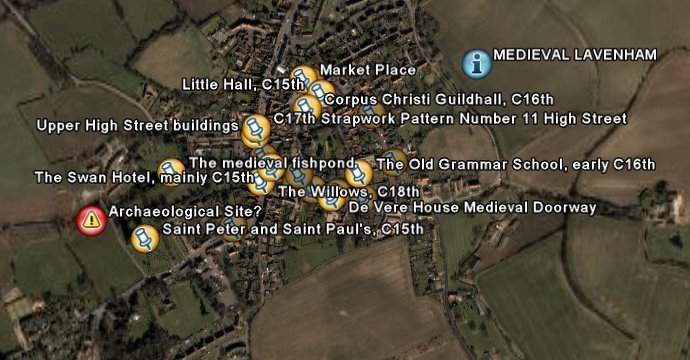
Medieval Lavenham


If the C19th is not your bag and you prefer your medieval to mills and Manchester then put your cod piece on and get on down to
Lavenham, Suffolk. Here we have a significant number of historic timber framed buildings with some archaeological and architectural features noted, including a potential archaeological site - do you know what it might be? Check out the red alert symbol on the map.

That concludes the update, more maps will be added shortly. Please make a comment if you find them useful.

Tuesday, January 03, 2006

Lavenham Archi-Map

My medieval google earth map of Lavenham is now almost complete you can get it here. You need to have Google Earth installed to view which you can access from the link above also.

Lavenham is a remarkable survival of a medieval town with primarily timber framed buildings dominating and a beautiful Perpendicular style church. It has over 300 listed buildings. In the map I have tried to show some interesting medieval features of timber framed houses.

On the map I have marked an interesting series of lumps and bumps which look like the archeaological remains of some dwellings to the west of Saint Peter and Saint Paul's church. I noticed them when I was compiling the map. I'm sure that there is some information about them out there - please comment if you know any more information. Great site for a dig!

Saturday, December 31, 2005

Archi-Maps Update


Well I have been working hard over the Christmas period on my Google Earth archi-map of Manchester and added a dozen or so mouth watering buildings of differing styles and time periods. To add more interest, I have also placed the buildings into timelines so that you can see what buildings were produced in a particular century. You can even do a chronological fly through of the buildings of Manchester if that takes your fancy.

Some of the buildings I have added include the Albert Memorial in Albert Square, The Mathematics Building on Oxford Road, and Aquatics Centre, Oxford Road.

Coming soon is a medieval archi-map of timber framed buildings of the famous wool town of Lavenham Suffolk UK.

Friday, December 16, 2005

Archi-Maps an introduction

For the past couple of months I have been working on providing an architectural map of Manchester via Google Earth. It is a time consuming (but enjoyable) exercise. Today I have completed the first phase of the map and put it on my website.

I will be adding more buildings as time goes on and there is an update feature available on my website. I will also be adding more city maps in the new year including Liverpool and Hull in the UK and Venice Italy.

The map utilizes the remarkable features of the Google Earth Satellite mapping system and highlights some of the key buildings of Manchester with a photograph, date, architect, and description. There are also links to other images of the building and directions for further information. What is remarkable is that all this information is available by clicking on placemark situated over the satellite image of the building itself.

Once you have downloaded the map, there are a number of things that you can do:-

  • You can view all buildings on the map
  • You can view selected buildings on the map
  • You can plan routes to and from the buildings
  • You can view buildings built within a certain century (I have provided themed time line folders)
  • You can at any time have a guided movie style tour of the buildings by clicking the play button in the places folder
You can get to my Archi- Map of Manchester here

If you like what you see, or have any suggestions then please leave a comment via this blog.

ARCHI-SEARCH

Custom Search