Archi-Maps Update

There's a lot been happening with my archi-maps project recently. The maps include photographs and links to relevant information. To use the archi-maps you need to have the free Google Earth installed. If you haven't seen Google Earth you'll wonder why you ever did without it. To get into Google Earth there's a great blog here. To download any of the maps go to my archi-map page : buildings are being added regularly so use the update feature on the page to keep up to date.
Manchester, UK archi-map

Manchester was the industrial hothouse of England during the Industrial Revolution and is now at the forefront of urban design with new structures by world renowned architects such as Calatrava and Ando.
More buildings have been added to my Manchester archi-map , the latest being the Victoria Bridge near the Cathedral. All buildings have been placed in relevant timeline folders so that you can view, for example, just buildings of the C19th etc.
Cheesden Valley, UK archi- map

Cheesden Valley with all mill locations and other features courtesy of Google Earth
The Cheesden Valley is, in my opinion worthy of World Heritage Status, it is a little known valley which witnessed the early stages of the industrial revolution (more here)
If you want to immerse yourself into the English early C19th then the Cheesden Valley archi-map is for you. Go to my Cheesden Valley blogspot and learn about the mills whilst you have the archi-map up and running. Ramp up your ELEVATION EXAGGERATION to the max (3) in 'Tools' /'Options and you will be able to fly through the valley and over the mills. Make sure you switch 'Terrain' on. I am updating each mill with a photo and data file - the latest addition being Cheesden Lumb Lower - the archaeological remains of a water powered mill dating from the C18th.
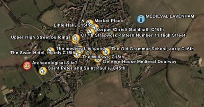
Medieval Lavenham

If the C19th is not your bag and you prefer your medieval to mills and Manchester then put your cod piece on and get on down to Lavenham, Suffolk. Here we have a significant number of historic timber framed buildings with some archaeological and architectural features noted, including a potential archaeological site - do you know what it might be? Check out the red alert symbol on the map.
That concludes the update, more maps will be added shortly. Please make a comment if you find them useful.


No comments:
Post a Comment